
Bend Bulletin - Ochoco Preserve restoration turns farmland to floodplain near Prineville
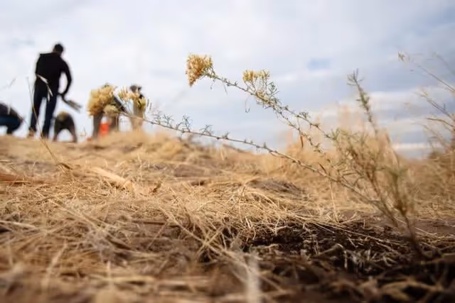
PRINEVILLE — On an exposed hilltop in the Ochoco Preserve outside Prineville, Gabriel Juarez carefully places palm-sized forbs inside shallow holes in the soft earth. He puts the herbaceous plants in strategic spots between the invasive cheatgrass and then sprinkles water over their tiny green leaves.
“We are trying to water these plants in after they are transplanted to give them the best shot at pulling through the transplant shock,” said Juarez, a stewardship associate with the Deschutes Land Trust, the Bend-based non-profit rehabilitating the preserve.
The collection of newly planted forbs is a portion of the nearly 200 plants going into the preserve on a recent weekday. The planting is part of a landscape rehabilitation project that will see many more thousands planted by the Land Trust, which is attempting a stream restoration of this former agricultural landscape.
The 185-acre Ochoco Preserve sits three miles from downtown Prineville on land that only a few years ago served as hay fields owned by two families. It is located where McKay and Ochoco creeks join the Crooked River.
Improving habitat
The farmland-to-floodplain conversion provides habitat and cover for animals and also helps clean local soil and water resources. When complete, it will also offer a convenient walking area for Prineville residents wanting to experience nature in their city’s backyard.
For most of the 20th century, the soil here was plowed up to grow crops, but that proved difficult due to the high groundwater table, uneven topography and springs, said Rika Ayotte, Deschutes Land Trust’s executive director.
In 2017 the Land Trust purchased the farmland for an undisclosed amount, intending to convert the land back to its natural state and connect it with the Crooked River Wetlands Complex on the opposite bank of the Crooked River, about half a mile away from the rehabilitation sites. The wetland complex itself is a landmark environmental project, providing wildlife habitat while doubling as a municipal wastewater treatment facility.
“We will build a bridge over the Crooked River that connects to the wetlands complex, extending that trail network that is beloved by the community,” said Ayotte.
Plans also include the construction of a bike path from Prineville, allowing residents to reach the wetlands complex without a car.
Work on the ground also required rerouting the creeks to rebuild the floodplain into a natural habitat that can attract fish and wildlife.
Felled juniper trees were placed into the streams, mimicking beaver dams to back up water and create habitat for wildlife.
“By re-meandering it through the floodplain you are slowing it down, you are allowing it to absorb into the groundwater, you are creating more diversity of habitat for fish and wildlife,” said Ayotte.
Shifting landscapes
The stream channels are designed to move around the property as natural forces shift the landscape over time.
“We have already had some high flow events and some rain on snow events that have changed the way the first phase looks,” Ayotte said.
Complicating the Land Trust’s effort is the large amount of soil piled up at the site, brought here in a failed attempt by the previous landowners to cover over the springs. Instead of hauling away the overabundant soil, the work crews have molded the dirt into small hills.
“From a cost perspective and a climate perspective (moving the soil) was not ideal,” said Ayotte. “It has been an interesting engineering process.”
Crowding out weeds
In addition to reshaping the landscape and improving streamflow, Juarez said a key part of the current restoration work is increasing the number of native flowering plants, which introduces competition to the weeds that have exploded on this landscape.
“Yarrow, penstemon, flax. Those are going to contribute to higher native plant densities and as a result, hopefully out-compete some of the invasive weeds,” he said.
Other native vegetation being planted here include fleabane, globemallow and scarlet gilia.
Juarez, with the Land Trust for three years, said removing the invasive weeds is particularly challenging when native plants are mixed into the area. The best strategy, he said, is to plant more native plants with the idea that they can eventually crowd out the invasive plants.
The replanting project is being done piecemeal “in small, manageable chunks,” said Juarez.
Repeat strategy
It’s a strategy employed by the Land Trust on similar projects in Central Oregon. The trust has been working with partners on the restoration of a 6-mile section of Whychus Creek near Sisters, where agriculture and flood control manipulated the landscape for decades. The project has occurred in phases over seven years, with at least one more phase remaining.
At the Ochoco Preserve, Ayotte said the battle to control weeds could take years. The amount of work that can be done is based on available resources and funds.
Volunteers are sometimes invited to the project site to help with the native vegetation planting. On a recent weekday, retired archaeologist Bill Hildebrandt was seen excavating small holes and watering freshly planted vegetation. He said he was motivated to do the work to improve Central Oregon’s ecology for fish.
“One of the main goals of the Land Trust is to restore fisheries by redirecting streams and creating good spawning habitat for salmon and steelhead as well as local trout. I think those are all good things, which is why I like to help out,” said Hildebrandt.
“There are already a few rainbow trout feeding down here in the stream, they probably weren’t doing that before when it was a straight ditch,” he said.
For now, most of the hills on the Ochoco Preserve remain barren. But Ayotte says the transformation of the land occurs with remarkable speed, pointing out one grassy hill planted only a year earlier. Over the next two years, the remaining acres will also be mulched, seeded and sown with native plants.
Trails are planned to meander through the area and along the creeks, allowing visitors a close-up view of the rehabilitation work. Ayotte expects most of the work to be completed by 2026.
